Assessing the Visual and Built Environment Risk on Pedestrian-Vehicle Crash Severity in Absence of Detailed Roadway Inventory: A Deep Learning Based Framework Harnessing Public Geospatial Data
Abstract
Pedestrian-vehicle crashes remain a major public health concern, yet many developing cities lack the detailed roadway inventories needed to assess how roadway environments influence crash severity. This study develops a data-driven framework that integrates visual and built-environment characteristics derived from publicly available geospatial data to predict pedestrian crash severity in resource-constrained settings.
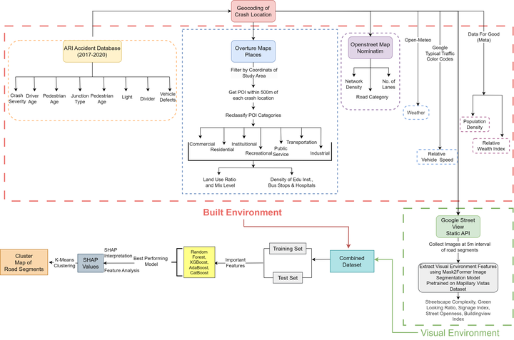
Methods: Police-reported pedestrian crash records from Dhaka, Bangladesh, were integrated with Google Street View imagery, Overture Maps, OpenStreetMap, and Meta sociodemographic data. Built-environment variables and visual indicators derived through semantic segmentation were extracted. Four machine learning models were developed for binary crash severity prediction. SHapley Additive exPlanations (SHAP) were used to interpret model predictions, and K-means clustering of SHAP values identified roadway environments with similar risk profiles. Findings: Extreme Gradient Boosting (XGBoost) achieved the highest predictive performance (F1 score: 79%). Network density and commercial, institutional, residential, and industrial land uses were associated with higher fatal crash risk. In contrast, recreational land use, greenery, signage, building visibility, Relative Wealth Index, and the density of schools, hospitals, and bus stops were associated with lower fatality risk. SHAP-based clustering identified three distinct roadway environments, highlighting substantial spatial heterogeneity in the effects of visual and built- environment factors on crash severity.
Novelty: This study presents an interpretable framework that combines computer vision-derived visual indicators with open geospatial datasets to assess pedestrian crash severity without requiring detailed roadway inventories. The framework demonstrates that publicly available data can generate scalable, context-sensitive safety insights for data-scarce transportation systems.
Practical Applications: The proposed framework enables transportation agencies to identify high-risk roadway environments and prioritize location-specific pedestrian safety interventions where conventional roadway inventory data are unavailable. The approach supports evidence-based infrastructure planning and resource allocation in rapidly urbanizing, data-scarce cities.

Tanvir Ahmed Sijan
Prospective PhD Applicant
My research interests lie at the intersection of NLP and AI safety, focusing on human-AI alignment through human-centered evaluation, alignment methods, and LLM interpretability to develop safer and more trustworthy language models.